

About the Santa Fe to Taos Thru-Hike
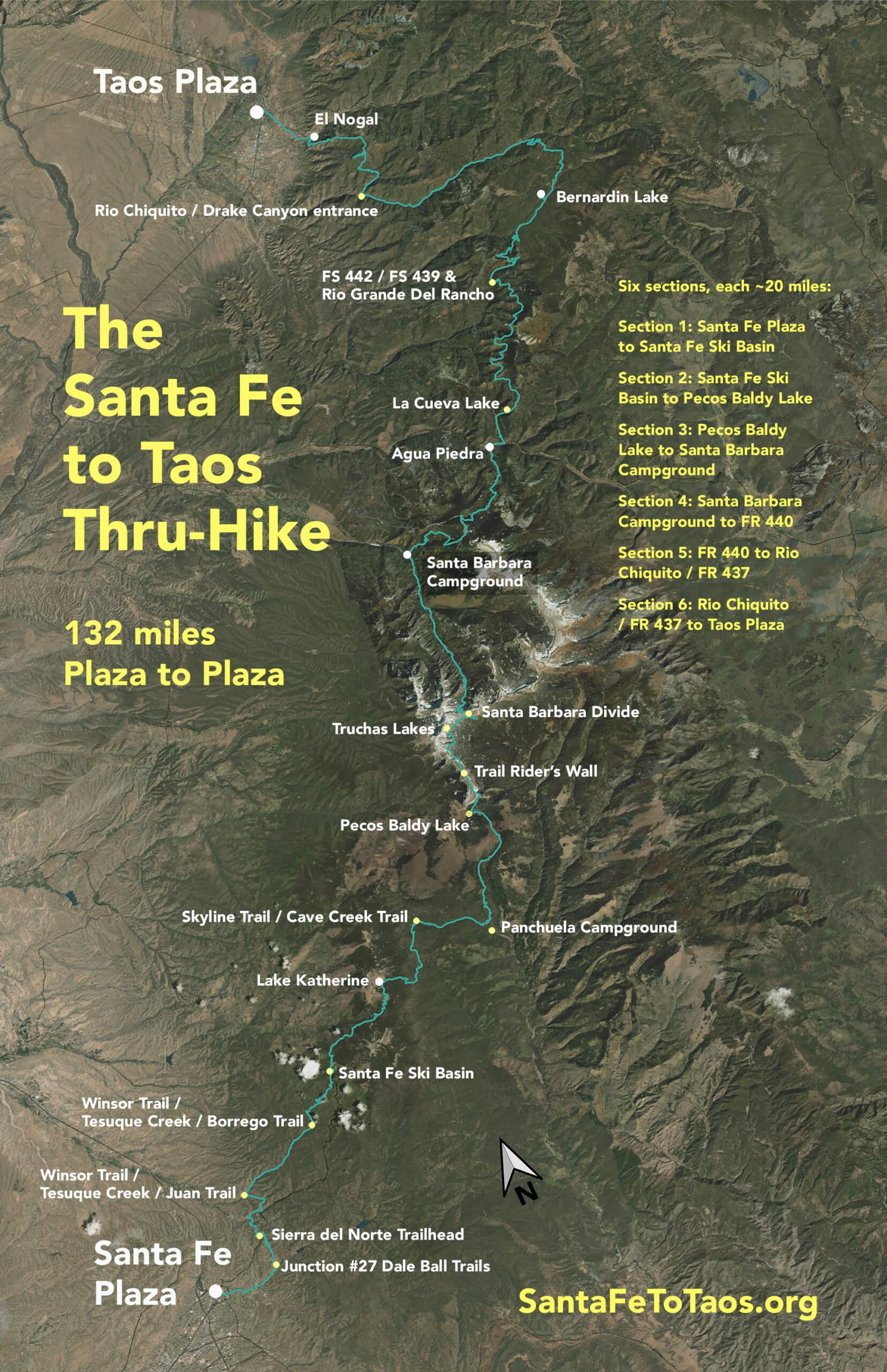
The Santa Fe to Taos thru-hike goes from the Santa Fe Plaza over the Sangre de Cristo Mountains all the way to Taos Plaza. It is 132 miles long and spans four counties – Santa Fe, Rio Arriba, Mora, and Taos. There are six sections to the thru-hike, each roughly 20 miles long.
The Santa Fe to Taos Thru-Hike is a 501(c)3, founded in the fall of 2023.
Key facts about the route of the thru-hike
- The route is all on existing trails or forest roads, with the exception of about 2,100 feet along state highways. The highway sections are about 1,500 feet along highway 518 near Sipapu, and about 600 feet along highway 585 in Taos. Both of those stretches have ample shoulder to walk on and no tight curves where a driver could be surprised by a pedestrian. No new trails need to be established.
- Trails conditions along the route are reasonably good. More than 80% of the thru-hike is on frequently-traveled trails, and even what is not frequently-traveled is still passable. Dockweiler Trail in the Pecos Wilderness, for example, is overgrown and has a few fallen trees. But anyone fit enough to get to that section of trail will be fit enough to get over a few fallen trees.
- The route was first established in 2018 when Pam Neely went from the Santa Fe Ski Basin through to Taos Plaza. Section 1 of the thru-hike, from the Santa Fe Plaza to the Santa Fe Ski Basin, was added in the spring of 2023.
- The entire route of the thru-hike can be done in day hikes and one to two-night overnights.
- The route does not go through any tribal lands, private property, or protected areas that don’t already have an easement for hikers. The only section of the thru-hike that goes through an easement is the “Santa Fe River Corridor” section (0.75-miles) between Camino Pequeno to Dale Ball Trails Junction #27.
- Should there be a need to change the route, there are enough alternate routes available on existing trails that the thru-hike could still connect the Santa Fe and Taos plazas. The question to ask isn’t if there’s a way from Santa Fe Plaza to Taos Plaza. The question to ask is what’s the most beautiful, “best” route to take?
- The route has 13 points that are possible exits or access points. This facilitates accessing the trail for day hikes and delivering supplies to thru-hikers. It also allows for access from emergency services.
- Much if not most of the thru-hike goes along rills (tiny streams 1-2 feet wide), creeks, and “rivers”. The longest distance on the thru-hike without access to water is 5.9 miles from FR 442 / Ojitos Maes Trail (#182) to FR 439 in Carson National Forest. Even in this stretch, there are a few seeps.
- The route is not yet marked as The Santa Fe to Taos Thru-Hike. One of the main goals for 2024 is to a) get permission to mark the full length of the trail and b) to get the trail markers posted.
A text description of the route of the thru-hike:
- Santa Fe Plaza to East Alameda Street
- East Alameda Street to Camino Pequeno/Santa Fe River Corridor
- Dale Ball Trails Junction #27 to Sierra del Norte Trailhead of the Dale Ball Trails
- Sierra del Norte Trailhead of the Dale Ball Trail to Trail 399 (Juan Trail)
- Trail 399 (Juan Trail) to Tesuque Creek/Winsor Trail 254
- Winsor Trail (254) to the Santa Fe Ski Basin
- Santa Fe Ski Basin / Winsor Trail to Skyline Trail (251) to Lake Katherine
- Lake Katherine to Stewart Lake along Winsor and Skyline Trails
- Stewart Lake via Skyline Trail (251) to Cave Creek Trail (288) to Dockweiler Trail (259)
- Dockweiler / Trail 259 to Jack’s Creek Trail (257) to Pecos Baldy Lake
- Pecos Baldy Lake / Skyline Trail (251) over the Trailrider’s Wall to Truchas Lakes
- Truchas Lakes / Skyline Trail (251) to Trail #25 (Westfork Trail) and the Santa Barbara Divide
- Santa Barbara Divide / West Fork trail north towards Santa Barbara Campground, picking up MIddle Fork Trail (#24) a few miles before you reach Santa Barbara Campground
- Santa Barbara Campground / Trail #27 (Indian Creek Trail) up to Ripley Point / Divide Trail (#36)
- Down from Ripley Point via Trail #22 (Comales Trail) past Los Esteros until you reach Agua Piedra Trail 19A and Agua Piedra Creek.
- Agua Piedra Trail 19A and Agua Piedra Creek into Agua Piedra Campground
- Agua Piedra Campground walking paths to Route 518 to Trail 492 to La Cueva Lake
- La Cueva Lake to Ojito Maes Trail (#182) to FS 442 to FS 439 to FS 439A back to a later section of FR 440 to unnamed trail (this unnamed trail exists on The National Map and can be easily seen in satellite photos, so I’m counting it as existing trail) to FR 438 / Diablo Canyon.
- FR 438 / Diablo Canyon via Trail 438 to Bernardin Lake
- Bernardin Lake / FR 438 to FR 478 to FR 437 / Rio Chiquito
- FR 437 / Rio Chiquito to Drake Canyon / Trail #165 (Drake Canyon Loop Trail) to Ojitos Trail (#166)
- Ojitos Trail (#166) to South Boundary Trail (#164) to Trail #164B, past the water tower, to Route 585
- Trail #164B/ Route 585 east for ~600 feet, then take the left on to Witt Road.
- Rt 585 / Witt Road to Route 64 (aka Kit Carson Road).
- From Witt Road / Kit Carson Road, walk into Taos Plaza. You will have reached Taos City limits when you pass Jaramillo Lane, which is also where the sidewalks start.
Gaia / GPS documentation of the route of the thru-hike is available here.
This is the summary map. You can get a printable version of this map that fits on an 8.5 x 11 sheet of paper here.
If you have any feedback, ideas, comments, etc about the thru-hike I would love to hear from you via email at contact@santafetotaos.com.
